


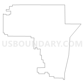
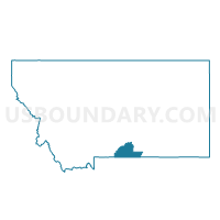
Precinct 12, Carbon County, Montana
About
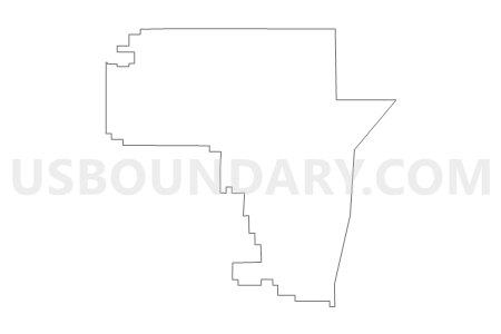
Outline
Summary
| Unique Area Identifier | 611848 |
| Name | Precinct 12 |
| County | Carbon County |
| State | Montana |
| Area (square miles) | 81.24 |
| Land Area (square miles) | 80.75 |
| Water Area (square miles) | 0.49 |
| % of Land Area | 99.39 |
| % of Water Area | 0.61 |
| Latitude of the Internal Point | 45.44791300 |
| Longtitude of the Internal Point | -108.75837940 |
Maps


Graphs
Select a template below for downloading or customizing gragh for Precinct 12, Carbon County, Montana


Neighbors
Neighoring Voting District (by Name) Neighboring Voting District on the Map
- Precinct 1, Carbon County, MT
- Precinct 15, Carbon County, MT
- Precinct 3, Carbon County, MT
- Precinct 42A, Yellowstone County, MT
- Precinct 5, Carbon County, MT
Top 10 Neighboring County Subdivision (by Population) Neighboring County Subdivision on the Map
- South Yellowstone CCD, Yellowstone County, MT (7,653)
- Crow Reservation CCD, Big Horn County, MT (6,553)
- Joliet CCD, Carbon County, MT (2,487)
- Fromberg-Bridger CCD, Carbon County, MT (1,756)
- East Carbon CCD, Carbon County, MT (711)
Top 10 Neighboring Place (by Population) Neighboring Place on the Map
Top 10 Neighboring Elementary School District (by Population) Neighboring Elementary School District on the Map
- Laurel Elementary School District, MT (11,043)
- Joliet Elementary School District, MT (2,039)
- Pryor Elementary School District, MT (732)
- Morin Elementary School District, MT (403)
Top 10 Neighboring Secondary School District (by Population) Neighboring Secondary School District on the Map
- Billings High School District, MT (127,987)
- Laurel High School District, MT (10,696)
- Joliet High School District, MT (2,386)
- Plenty Coups High School District, MT (732)
Top 10 Neighboring Unified School District (by Population) Neighboring Unified School District on the Map
Top 10 Neighboring State Legislative District Lower Chamber (by Population) Neighboring State Legislative District Lower Chamber on the Map
- State House District 57, MT (11,941)
- State House District 59, MT (9,089)
- State House District 42, MT (8,534)
Top 10 Neighboring State Legislative District Upper Chamber (by Population) Neighboring State Legislative District Upper Chamber on the Map
- State Senate District 29, MT (22,035)
- State Senate District 30, MT (19,092)
- State Senate District 21, MT (17,554)
Top 10 Neighboring 111th Congressional District (by Population) Neighboring 111th Congressional District on the Map
Top 10 Neighboring Census Tract (by Population) Neighboring Census Tract on the Map
- Census Tract 9400, Yellowstone County, MT (7,653)
- Census Tract 1, Carbon County, MT (2,487)
- Census Tract 2, Carbon County, MT (1,756)
- Census Tract 9405, Big Horn County, MT (1,436)
- Census Tract 5, Carbon County, MT (1,354)
Top 10 Neighboring 5-Digit ZIP Code Tabulation Area (by Population) Neighboring 5-Digit ZIP Code Tabulation Area on the Map
- 59101, MT (39,562)
- 59041, MT (1,950)
- 59014, MT (1,446)
- 59029, MT (733)
- 59066, MT (701)
- 59026, MT (194)